It has long been recognized that the area in southern Britain known as Wessex, and Armorica in northern France were strongly linked during the early Bronze Age. This is evidenced by numerous exotic materials and artefacts of the most exquisite craftsmanship that originated in places far away from where they were deposited. The early Bronze Age elites along the Channel coastlands shared symbolically significant items through trade and exchange in prestige grave goods, while wider communities seemed to benefit indirectly from these networks as represented by strong regional traditions expressed through material culture such as pottery. While the exchange of goods is well highlighted on both side of the Channel, there have been few investigations about the kind of societies involved and their related territories. However this question is crucial for understanding the mechanisms and the structures of maritime trade. Through the analysis of territorial, social and economic structures, researchers at Bournemouth University aim to define what kind of societies supported cross-Channel connections.
Wessex-Armorica: Territories, Connections & Hierarchies (WATCH) is a Marie Skłodowska-Curie funded project (MSCA-IF-2018, no. 841128) led by Dr Clément Nicolas and supervised by Professor Tim Darvill at Bournemouth University and in partnership with Wessex Archaeology. The aim of the project is to model the organisation of territories, economic and political connections, and social hierarchies promoted and sustained by maritime connections across and around the English Channel during the early Bronze Age (2100-1600 BCE). This study is crucial to understand how communities living in the Channel coastlands became interdependent at a time when trade in tin and copper was strengthening the foundations for an extensive prehistoric European union.
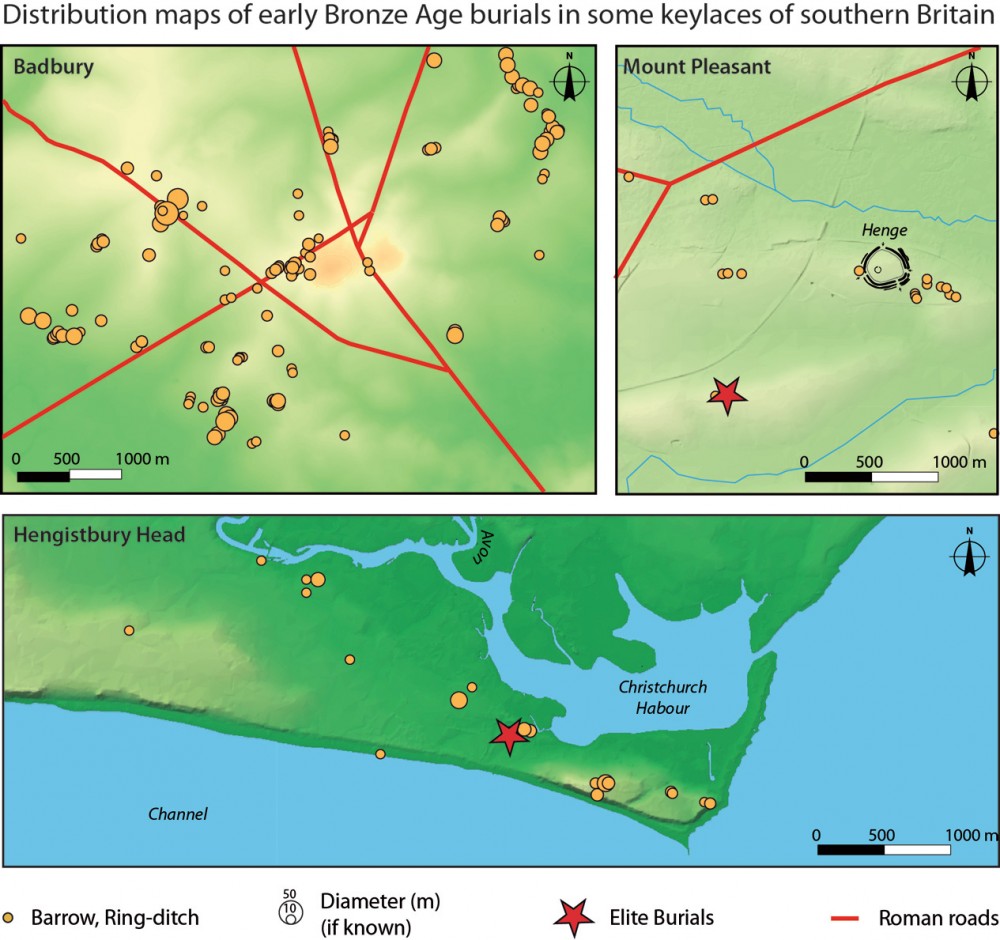
Analysing data from Dorset, Hampshire & Wiltshire
Central to the project is the study of burials within their human, social, and natural environments using Geographical Information System (GIS) analysis. The project is interdisciplinary, rooted in archaeology but borrowing concepts, methods, and data from geography and environmental sciences. In particular, the project aims to build a database collecting data on burials and unexcavated barrows and ring-ditches in central southern England (Dorset, Hampshire & Wiltshire).
The database will be used to define social hierarchies in the area with considerations to adjacent counties in southern England. Spatial analysis will compare distribution of burials with early Bronze Age human settings (enclosures, settlements, field systems, sacral places and terrestrial & maritime roads) and environment (topography, hydrography soil fertility) with the aim to identify specific patterns within territorial organisation. Finally results from southern England will be compared with previously acquired data from early Bronze Age Arrmorica, where strong territorial patterns has been observed: grave goods show a social geography in the landscape, while elite burials are found in the middle of coherent territories, managed through land divisions (field systems), along terrestrial roads (the so-called ‘Roman roads’) and natural harbours (estuaries).
Defining the territorial and social structures of early Bronze Age Wessex
For this on-going project, a dedicated database has been built up with open source software (LibreOffice), allowing open access dissemination. The database is currently in the process of being compiled with burials from Dorset, while it is expected to reach 5,000-6,000 monuments (barrows, ring-ditches) for the whole area under consideration.
Preliminary observations confirm previous researches highlighting noteworthy concentrations around Late Neolithic henges (Fleming 1971, Woodward & Woodward 1991), which show signs of re-use during the early Bronze Age (Mount Pleasant, Knowlton Circles, similarly to Stonehenge area). Nevertheless, they show as well striking correspondence with ‘Roman roads’, with concentrations of early Bronze Age monuments around crossroads, including barrows set in line along the roads, such as those found at Badbury (Shapwick). In a similar way, the Hengistbury Head barrow cemetery (Bournemouth) dominating the mouth of River Avon, connecting the channel to Stonehenge area suggests a close control of this natural harbour and gateway to the continent. Such concentrations are linked with monumental barrows and elitarian grave goods, such as gold exotic items, arrowheads.
The territorial and social structures of early Bronze Age Wessex remained to be defined in detail. However while first observations show clear regional specificities, such as the significant re-use of henges as central points in the landscape, southern British data offer strong similarities with what happened on the other side of the Channel. It seems that beyond elite burials, we are faced with highly stratified societies within defined polities, thus questioning their socio-economic organisation between ‘chiefdoms’, as often agreed, and states, as purposed by Fleming (1971). In this respect, the WATCH project offers new insights on the development of social stratification and control over trade networks across the Channel, nowadays one of the world’s busiest sea routes.
References
Fleming, A. 1971. Territorial Patterns in Bronze Age Wessex, Proceedings of the Prehistoric Society, 37, 138-166.
Woodward, A.B., Woodward, P.J. 1996. The Topography of some Barrow Cemeteries in Bronze Age Wessex, Proceedings of the Prehistoric Society, 62, 275-291.


